Viewranger. GPS mapping software designed for walkers, cyclists, ramblers and anyone who likes to stray off the beaten path. No fast food points of interest in this puppy, we’re talking next tree on the left, after that bush type of stuff. You can record your trip, ‘share your experiences’ and most importantly track your buddy so you know where they are at all times. £24.99 and a Symbian S60 phone takes you outbacking in style.
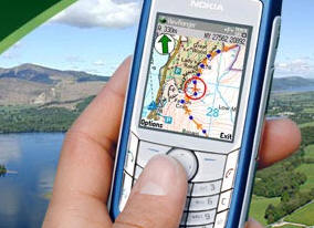
ViewRanger is a unique mapping, navigation, tracking, and information tool for mobile phones that provides information about your immediate surroundings through a natural and intuitive display. On a phone with a built-in internal GPS, or with a Bluetooth GPS receiver connected, ViewRanger transforms a Nokia or other Symbian S60 smartphone into a fully featured trail navigation system.


interesting software. I bet the installed files will be small since not much will be in those maps….cut the burger joints. You’d rather add in POIs like jungle trails ,etc
Colbert, that’s what I thought. But the maps come on a 4GB microSD. So much for that theory. :-) Clearly there’s a *lot* of bushes mapped on there.
That might be a bit of a deal killer for this software. I’m not sure how many phones will accept a 4Gb microSD and not that many phones use the microSD cards …. yet.