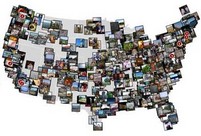
Mapr. Maps + photos via Flickr = Mapr. Pretty cool way of looking at the world (OK, so the US only at the moment) via everyday snapshots taken by the public. It’s still beta, as can be seen from the fact that a photo from Richmond Park here in London has been wrongly attributed to a town called Deer in Arkansas. Oh well, I’m sure it’ll get better.
Mappr is an interactive environment for exploring place, based on the photos people take. By adding geographical information to the wealth of photographs found on Flickr, it allows new ways of looking at spaces and images. Mappr adds place to pictures.